


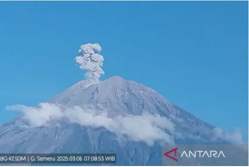
SEAToday.com, Jakarta - Mount Semeru, located on the border of Lumajang and Malang regencies in East Java, remains on alert status after experiencing multiple eruptions on Monday.
The volcanic eruptions sent ash columns soaring between 400 and 1,100 meters above the summit.
The first eruption occurred in the early hours at 12:54 AM WIB, producing an ash column approximately 600 meters high. The volcanic ash was observed to be white to gray in color with moderate intensity, drifting southward.
Shortly after, at 1:04 AM WIB, another eruption took place, with a slightly lower ash column of about 400 meters. Similar to the first event, the ash plume displayed a white to gray hue and moved in a southern direction.
"Mount Semeru erupted again at 2:04 AM WIB, generating an ash column of about 1,000 meters above the summit. The volcanic ash, exhibiting a white to gray coloration with moderate intensity, was observed drifting southward," reported Liswanto, an official from the Mount Semeru Observation Post, in a written statement received in Lumajang, as quoted on Antara.
Another eruption was recorded at 2:33 AM WIB, producing an ash column reaching approximately 700 meters above the summit. The pattern of white-to-gray ash dispersing southward continued.
At 2:43 AM WIB, Mount Semeru erupted once more, sending an ash column 1,000 meters into the sky. The tallest recorded eruption of the day occurred at 3:15 AM WIB, with an ash column soaring 1,100 meters above the peak.
The highest volcano on the island of Java continued its activity with additional eruptions at 4:07 AM WIB, 4:30 AM WIB, and 5:22 AM WIB, each producing ash columns approximately 1,000 meters high or reaching an altitude of 4,676 meters above sea level.
At 6:16 AM WIB, another eruption occurred, producing an ash column around 900 meters above the summit (4,576 meters above sea level).
"The ash column was observed to be white to gray with thick intensity, moving south and southwest. The eruption was also recorded on seismographs with a maximum amplitude of 22 mm and a duration of 113 seconds," the official added as quoted on Antara.
In response to the ongoing volcanic activity, the Center for Volcanology and Geological Hazard Mitigation (PVMBG) issued several safety recommendations for the public. Residents and visitors are strictly prohibited from engaging in any activities within an eight-kilometer radius of the southeastern sector along Besuk Kobokan, as it remains the primary danger zone.
Beyond this distance, people are advised to stay at least 500 meters away from riverbanks along Besuk Kobokan due to the risk of pyroclastic flows and lava reaching up to 13 kilometers from the summit.
"Residents must also avoid activities within a three-kilometer radius of Mount Semeru’s summit to prevent exposure to incandescent rock ejections," the PVMBG emphasized as quoted on Antara.
Authorities have also urged residents to remain vigilant against potential pyroclastic flows, lava avalanches, and rain-induced lahars along rivers and valleys originating from Mount Semeru’s peak. The areas most at risk include Besuk Kobokan, Besuk Bang, Besuk Kembar, and Besuk Sat, as well as small tributaries connected to Besuk Kobokan.
As Mount Semeru remains active, authorities continue to monitor the situation and advise the public to follow official warnings to ensure their safety.
Writer: Andi Raisa Malaha Thambas